

Google Earth Pro is a powerful mapping and visualization application that allows users to explore satellite imagery, 3D buildings, terrain, geographic data, and historical imagery from around the world.
It is designed for both casual users and professionals who need tools for geographic research, education, planning, presentations, and spatial analysis. Users can search for locations, measure distances and areas, create custom maps, import geographic data, and explore changes over time.
What's New
- Improved satellite imagery and map visualization.
- Enhanced support for geographic data and map layers.
- Improved historical imagery and timeline features.
- Better performance and stability.
- Improved measurement and drawing tools.
- Enhanced KML and KMZ data support.
- Improvements to image export and printing.
- Various bug fixes and usability improvements.
Key Features
- High-Resolution Imagery – Explore satellite and aerial imagery from locations around the world.
- Historical Imagery – View older satellite images to see how locations have changed over time.
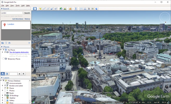
- 3D Buildings and Terrain – Explore cities, landscapes, and landmarks using detailed 3D models.
- Search and Navigation – Quickly find addresses, landmarks, businesses, coordinates, and other locations.
- Measurement Tools – Measure distances, areas, paths, and other geographic features.
- Drawing and Annotation – Add placemarks, lines, paths, polygons, and descriptions to maps.
- GIS Data Support – Import and view geographic data such as KML and KMZ files.
- Custom Maps – Create and organize custom locations and map projects.
- Image Export – Save high-resolution map images for presentations and reports.
- Tour Creation – Create guided tours using locations, paths, and camera movements.
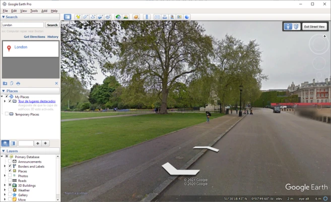
- Street View – Explore streets and locations using available Street View imagery.
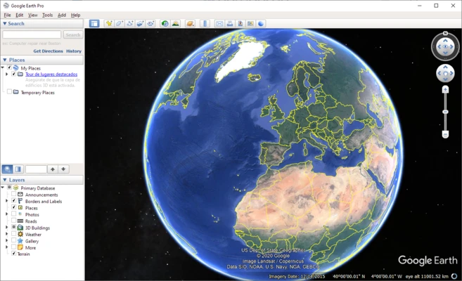
- 3D Globe – Navigate around the Earth using an interactive 3D environment.
User Interface
Google Earth Pro features a straightforward interface centered around an interactive 3D globe.
The left sidebar provides access to search, places, and map layers, while the toolbar contains commonly used tools for navigation, measurements, drawing, and other functions.
Users can zoom, rotate, and move around the globe using a mouse and keyboard. The interface is relatively easy to learn, while the additional mapping tools provide more advanced functionality for professional users.
Installation and Setup
- Download the Google Earth Pro installer for your operating system.
- Run the installer and follow the on-screen instructions.
- Launch the application after installation.
- Use the search box to find a location or address.
- Enable or disable map layers according to your needs.
- Sign in with a Google account if required for specific features.
How to Use
Search for a Location – Enter an address, city, landmark, or coordinates into the search box.
Navigate the Globe – Drag the map to move around, use the mouse wheel to zoom, and rotate the view to explore locations from different angles.
Use Map Layers – Enable layers such as roads, borders, places, and 3D buildings from the Layers panel.
Measure Distances and Areas – Use the measurement tools to calculate distances, paths, or areas on the map.
Create Annotations – Add placemarks, paths, and polygons to highlight specific locations or areas.
View Historical Imagery – Use the historical imagery feature to compare older satellite images with newer imagery.
Import Data – Import supported geographic files to display custom locations and datasets.
FAQ
Is Google Earth Pro free?
Yes. Google Earth Pro is available for free on desktop platforms.
Can I use Google Earth Pro offline?
Some previously loaded content may remain available offline, but many features and map data require an active internet connection.
Can I import my own map data?
Yes. The application supports formats such as KML and KMZ and can work with other geographic data through supported import features.
Can Google Earth Pro show historical images?
Yes. Historical imagery allows users to view available satellite and aerial images from previous years.
Can I measure distances and areas?
Yes. Built-in measurement tools can be used to measure distances, paths, and areas.
Can I use Google Earth Pro for professional work?
Yes. It can be useful for education, research, presentations, planning, geographic exploration, and other professional applications.
Alternatives
QGIS – Open-source GIS software with extensive mapping and geographic data analysis capabilities.
Global Mapper – Professional mapping and GIS software designed for working with spatial data.
Bing Maps – Microsoft's mapping platform for exploring locations, maps, aerial imagery, and geographic information.
Pricing
Google Earth Pro is available for FREE for desktop use.
System Requirements
- Operating System: Windows, macOS, or Linux
- Processor: 1 GHz or faster
- RAM: 2 GB or more
- Storage: At least 2 GB of available disk space
- Graphics: DirectX 9 or OpenGL-compatible graphics hardware
- Internet: Required for downloading map imagery and online geographic data
For smoother performance when viewing detailed 3D imagery, historical data, and large datasets, a more powerful processor, additional RAM, and a modern graphics card are recommended.
PROS
- Free to use
- High-quality satellite and aerial imagery
- Historical imagery
- 3D buildings and terrain
- Useful measurement and annotation tools
- Supports KML and KMZ data
- Available for multiple desktop platforms
CONS
- Many features require an internet connection
- Imagery quality varies by location
- Some geographic data may not be available in every region
- Advanced GIS analysis is more limited than dedicated GIS software
Conclusion
Google Earth Pro is a versatile desktop mapping application for exploring the Earth, viewing satellite imagery, analyzing geographic information, and creating custom maps.
Its combination of satellite imagery, historical data, 3D visualization, measurement tools, and geographic data support makes it useful for students, educators, researchers, professionals, and general users.
For users who need a free and easy-to-use tool for geographic exploration and basic mapping tasks, Google Earth Pro remains a solid choice.